

LiDAR, short for light detection and ranging, is a remote sensing technology that uses light in the form of a pulsed laser to measure ranges (distances) to a target.
A LiDAR sensor fires off beams of laser light and then measures how long it takes for the light to return to the sensor.
The laser precision of LiDAR together with field referencing (Total station surveying) and GIS processing, can visually map the environment.
The DOST funded the Phil-LiDAR Program to compliment other DRRM initiatives using LiDAR in 2014. The program serves as an urgent response to the pressing need for effective and efficient disaster risk reduction and management strategies particularly for flooding.
It was spearheaded by University of the Philippines Diliman (UPD) and co-implemented by fourteen (14) Higher Education Institutions (HEIs) such as the Central Luzon State University (CLSU).
An Ecological Profile (EP) is the more comprehensive replacement of the usual socioeconomic profile which gives equal coverage to the physical, biological, socioeconomic, cultural and built environments.
The Ecological Profile is a merger of the socioeconomic profile (SEP) and biophysical profiles of the study area and treats these subjects on equal footing.
This is the preferred form and LGUs are encouraged to shift from the SEP to the EP.
Sustainable development is part of the process of biodiversity conservation.
It also includes in-situ conservation, in which the ecosystem is conserved and protected, and the complete biodiversity is protected.
Ex-situ conservation, on the other hand, refers to efforts taken when an organism is at risk of becoming extinct. As a result, as mentioned below, biodiversity conservation strategies attempt to preserve, maintain, conserve, restore, and increase biodiversity.
Phytoremediation is a plant-based approach, which involves the use of plants to extract and remove elemental pollutants or lower their bioavailability in soil (Berti and Cunningham, 2000).
Plants have the abilities to absorb ionic compounds in the soil even at low concentrations through their root system.
Plants extend their root system into the soil matrix and establish rhizosphere ecosystem to accumulate heavy metals and modulate their bioavailability, thereby reclaiming the polluted soil and stabilizing soil fertility (Ali et al., 2013; Jacob et al., 2018; DalCorso et al., 2019).
There are advantages of using phytoremediation, which include: (i) economically feasible—phytoremediation is an autotrophic system powered by solar energy, therefore, simple to manage, and the cost of installation and maintenance is low, (ii) environment and eco-friendly—it can reduce exposure of the pollutants to the environment and ecosystem, (iii) applicability—it can be applied over a large-scale field and can easily be disposed, (iv) it prevents erosion and metal leaching through stabilizing heavy metals, reducing the risk of spreading of contaminants, (v) it can also improve soil fertility by releasing various organic matters to the soil (Aken et al., 2009; Wuana and Okieimen, 2011; Jacob et al., 2018).
During the past decades, numerous studies have been conducted to understand the molecular mechanisms underlying heavy metal tolerance and to develop techniques to improve phytoremediation efficiency.
In the current review, the mechanisms of how heavy metals are taken up and translocated in plants are described, and the detoxification strategies (avoidance and tolerance) adopted by plants in response to heavy metal have been discussed.
The main objective is to overview the recent advances in developing phytoremediation techniques, including the strategies to improve heavy metal bioavailability, tolerance, and accumulation. This review also highlights the application of genetic engineering to improve plant performance during phytoremediation.
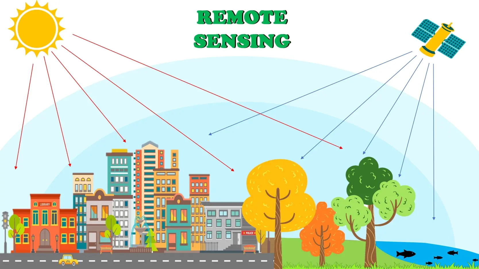
Remote sensing provides fast and efficient monitoring which includes indirect access to certain places. It also enables us to collect data about a subject or phenomenon without making physical contact with the object. This can be very useful for extraction of valuable information especially for areas that are now vanished or inaccessible to humans, observing the historical changes of a place via imageries or by monitoring certain locations far from reach or in outer space.
In modern times, remote sensing satellites or aircraft equipped with sensors observing the earth can detect changes and classify objects (Paz-Alberto et al., 2016).
You may check this paper for more info: LinK